The Trans Canada Trail, a.k.a. The Great Trail, is the longest chain of recreational trails worldwide and extends for some 27,000 km. Coast to coast to coast, this sixty-foot-wide-by-over-27,000-kilometer network of trails connects urban centers with small towns, forests, rivers, and mountains-walking, hiking, biking, and outdoor experiences like no other. It depicts the mixed nature of Canada-a coastline with rocky shorelines in the east, boreal forests in the middle, and majestic mountains in the west.
Highlights of the Trail
The Trans Canada Trail has something to offer every kind of walker. Some of the most noteworthy ones are as follows:
Atlantic Canada
Eastern avenues trace shores of Nova Scotia, Newfoundland, and river valleys in New Brunswick. These scenic routes offer garnished views of the ocean, fishing villages with stories, and wildlife. Many sections run somewhat flat and easy, making them perfect for family walks.
Central Canada
In Ontario and Quebec, trails link interior neighborhoods, forests, and river paths. Waterfront trails in Ontario and scenic rural tracks in Quebec present opportunities to further connect walks in nature with cultural exploration. Historical markers and local heritage sites pepper these paths, giving depth to every step taken.
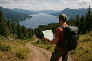
Western Canada
The western stretches go along prairies, mountains, and lakes. Hikers in Alberta and British Columbia will witness alpine trails, views of mountain ranges, and deep forests. Because of elevation gain, rough terrain, and longer distances, higher levels of fitness and preparation are usually required here.
Northern Territories
The more northern portions of the trail offer remote and wild experiences across the four provinces consisting of Yukon, Northwest Territories, and Nunavut. These sections are less developed and require careful planning with the suitable equipment and some backcountry navigation experience. After all, in return, hikers are given the gift of solitude amongst some of the best landscapes, wildlife, or bearing occasions.
Planning Your Trans Canada Trail Adventure
With respect to the length and variety of experiences, it is of utmost importance to plan one’s journey on the Trans Canada Trails. Begin by matching those areas of the trail to your fitness level or interests and time availability. Day walks, multi-day hiking, and long walking distances all require different preparations.
Some of the most important things that need to be considered in planning are:
- Route Info: Distances, elevation changes, trail surfaces, accessibility. Maps, guidebooks, and online trail resources are exceptional planning resources for more detailed planning.
- Safety and Supplies: Carry the essentials: water, food, suitable clothing, a first-aid kit, and navigation instruments. In case of a really remote part, do consider bringing a GPS or at least maps which work offline.
- Weather Awareness: Fast-changing weather conditions characterize Canadian weather. Especially in mountain and northern terrains, always await sudden changes in temperature, rainfall, or snow.
Most hikers attempt section by section instead of doing the entire network. Given such modularity, the trail allows you to enjoy several types of scenery while avoiding the commitment that a full cross-country trek requires.
Seasonal Considerations on the Trail
The Trans Canada Trail spans diverse climates and ecosystems, meaning that trail conditions change significantly throughout the year. Spring and summer are ideal for most walkers, offering green landscapes, blooming wildflowers, and extended daylight hours. Many coastal and northern sections are most accessible during these months, making sightseeing and wildlife observation easier and more enjoyable.
Interactive Map and Trail Details
The Trans Canada Trail’s interactive map provides a walker’s guide to locating trail segments, arranging itineraries, and finding points of interest nearby. Map features include:
- Trail Sections: Graphical display of each provincial and territorial section.
- Distance and Duration Estimates: Gives an idea about the effort put in each part of the trail.
- Points of Interest: These are cultural sites of significance, lookouts, water-crossings, and wildlife areas.
- Surface Type and Accessibility: Refers to paved, gravel, or dirt paths, and areas accessible by wheelchair or stroller.
- User Reviews and Updates: A member of the walking community can provide feedback on the condition of the trails and any changes affecting such condition throughout the year, and also give hints on the local culture.
It is possible to filter activities by level of difficulty, type of scenery, or preferred activity, so all you have to do is choose a goal and activities suitable for your abilities.
Tips for a Successful Trail Experience

Walking this Trans Canada Trail can be very rewarding, but good planning is needed. Consider these tips:
- Start Small: Do short lengths before longer ones.
- Equipment: Good shoes, clothes that can be layered for various weather changes.
- Stay Hydrated & Eat: Water and food in such quantities that its needed for the entire walk, especially when it is isolated and hard.
- Respect Wildlife and Nature: Do leaving-no-trace work to allow future visitors to enjoy it.
- Check Local Guidelines: Camping, fires, and pets are ruled differently by province or territory. Similarly, the rules regarding the use of trails vary per province or territory.
Everything You Need for a Great Walk
Trans Canada Trail provides one-of-a-kind walking adventure tying the peoples of this vast country to landscapes and communities. From urban trails to pathways winding in solitude through wilderness-we have every kind of walker and adventurer covered. Safety-first and Environmental guidelines come first for walkers to enjoy a memorable and enriching experience by good planning, interactive maps, and the use of those guidelines.
